All Green Maps

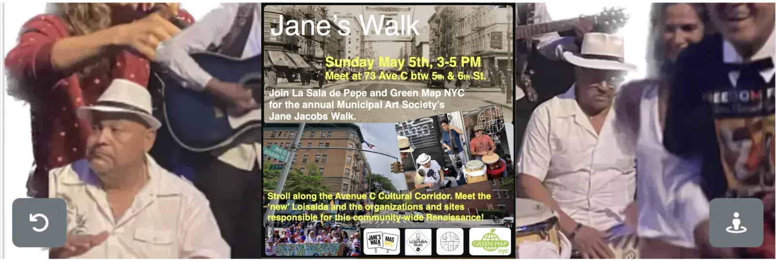
Beginning in May 2024, you can help map this emerging cultural corridor including the visual arts, music, architecture, gardens and foodways that have blossomed along Avenue CAdd to this map - bit.ly/avecadd  Share this map - bit.ly/avecmap24Our LES History Month + Jane's Walk event:Stroll Avenue C - the heart of Loisaida - with three community leaders: an international mapmaker, an urban anthropologist, and a spoken word poet for an ‘inside’ intro to the visual arts, music, architecture, gardens and foodways that have blossomed along Avenue C. 

Green Map NYC

Charting the ever-changing environment of New York City!

This map shows the spatial vision for Gorebridge and District and showing the links to the Forth National Planning Framework.

In 2024, join us in creating a fresh perspective on food production, education and enterprise starting in lower Manhattan and eventually, all of  NYC.

UNM Biodiversity

UNM main campus relatively safe and comfortable environment for students with plazas, grassy areas, comfy indoor spaces, and study areas with great views. But campus is also home to a lot of non-humans, some more hidden than others. There are the ducks at the pond who have become unafraid of you, snails that you'll only see when it rains, and even bird parents raising chicks in mature trees. This map is for documenting UNM's biodiversity to eventually help others get to know what other creatures share the campus environment.   

default

The Capital Regional District Development map features completed, in-progress, and planned developments in the CRD. The features on this map have been pulled from the Capital Regional Housing Corporation, and symbolize current and future affordable housing projects that address the housing needs of the CRD. 

default

Welcome to the RUSH flowering tree map, where you can plot a variety of flowering trees using our custom icons! This maps seeks to expand the 'Spring Blossoms in the City of Victoria' map, and to concretize the connectivity of our region's flowering trees. These beautiful trees provide a bountiful food source for pollinators, ample canopy cover, and remind on-lookers to stop and smell the roses.  We invite you to plot the flowering trees you spot on this map, and include a photo so we can all marvel in the beauty of the blooms.

Locations of stores and restaurants that provide access to Cultural Foods.

RUSH - Wood Wide Web

We want your help to map the trees in your neighbourhood! Please follow these steps to add data to the map: 

Local Community Wellbeing & Climate Resilience Mapping is a process to empower Community Climate Coaches to guide community members in mapping their local strengths and resources, which will contribute to the development of Community Wellbeing and Climate Resilience Pathway for each Municipal District of County Tipperary.

Local Community Wellbeing & Climate Resilience Mapping is a process to empower Community Climate Coaches to guide community members in mapping their local strengths and resources, which will contribute to the development of Community Wellbeing and Climate Resilience Pathway for each Municipal District of County Tipperary.

Welcome to the RUSH 'Shelter' map,  where shelter transcends mere physical structures to encompass the diverse spaces that offer safety and belonging. From cozy cafes to serene parks and vibrant community centers, each marked spot represents a sanctuary where individuals find solace and camaraderie. This map serves as a collaborative resource hub, inviting all to share and discover the places that make us feel truly at home. Together, we create a living archive of cherished spots that embody the essence of comfort, and acceptance within our community.

This is the map related to our project.

Mapping restoration sites as described by Peninsula Streams Society for the RUSH Initiative

This is the map aims to record the levels of Rhubarb growing taking place in the Dunoon and wider Cowal area, as part of Dunoon Goes POP 150 bottles project with Dunoon Burgh Hall.

Celebrating the whole of NYC at the Open Engagement festival, this mapping project utilized the famous NYC Panorama at Queens Museum, a giant 3-D map of the city. This workshop was created by Los Hibridos and Green Map NYC in spring 2014, and participants came from all over the world. We all enjoyed exploring the sites at the far ends of the city simply by walking around this "indoor helicopter tour of New York".

We want your ideas for things to include ! 

default
Les Classes d'Eau

La carte identifie les écoles qui participent au programme Classes d'eau et les éléments identifiés lors des campagnes. 

This is the map related to our project.

Significant Trees

Trees are a great way to connect people and nature. They are often focal points in a community and old friends from childhood. While there are projects to record veteran and champion trees, we think any tree can be significant to someone and is worthy of recording and celebration. That’s why, in collaboration with UCC BEES we have established a Significant Tree recording scheme that will allow people to record and map significant trees in their communities. Significant Trees can be old, unusual species, connected to local folklore, beautiful, or simply a tree you love!

default

This is the map related to our project.

The Highlands & Islands Climate Hub invites a membership of changemakers across Highland and the Northern Isles interested and supporting community led climate action across the region. Our Membership Directory and Member's Map shows our many members including where their specific interests are. Each listing will direct you to that Member's website or social media pages where you can find out more about them. If you would like to learn more from one of our Member's please get in touch with us at enquiries@hiclimatehub.co.uk and we will be happy to introduce you. Not yet a member? You can join as your community organisation, associate member or as an individual on our website https://www.hiclimatehub.co.uk 

This map is a collaboration between Dunoon Community Development Trust and the Shaping Places for Wellbeing Programme. It features community-led growing initiatives in the Dunoon and Hunter's Quay areas that include a focus on food growing.  Some of the projects are well established and others are just getting started or are at the planning stages.

[16, 6, 1, 6]
[]
[]
[]
[]
[]
[]
[]
[]
[10, 6]
[10, 10]
[10, 20]
[10, 30]
[]
[]
[]
[]
[]
[]
[]
[]
[]
[]
[]
[]
[]
[]
[]
[]